Sunday, June 26, 2016


Monday, June 20, 2016
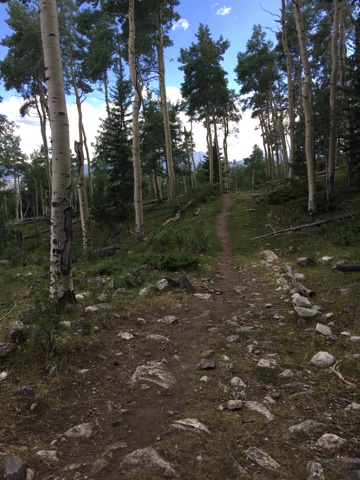
Conundrum Peak

Do you ever wonder if there is a specific plan for your life? I completely believe there is for everyone, and it is more fulfilling than any plans we can make for ourselves. The problem is, not everyone taps into that plan, or experiences it. Sometimes you have to take a step back and let God do the planning. Life is kind of like a mountain in the sense that usually the summit is not visible until the end. The general direction is many times known, but you have to take one step before you know how or where to take the next one. I completely believe that to experience God's best for your life you have to lose control of your own life and stop stressing over decisions. Let God work out the details for you and enjoy everyday.
This really doesn't have anything to do with Conundrum Peak other than it has been my favorite day so far of 2016 and I am currently listening to a song with the lyrics of
"It's not too late, I have a plan for you. It's going to be wild, it's going to be great, it's going to be fun"
{ Emphasis on the fun ;) }
 I've always known I have a strong desire and calling on my life to make art, but my art has gone in a direction I would have never predicted, and I can guarantee it'll eventually go in a new direction. You know when there is a peace in your heart that shows you that you are in the right place at the right time? Although this trip did scare me a few times I felt that peace on this trip. That peace can never be bought, sold or created. It can only come from one place.
With that being said, here is my trip report.

We left just below the creek crossing around 5:15 am. I learned the proper way to put on my crampons through Joel, apparently I had it all wrong :)

There was A LOT of snow. We reached the ridge between Castle and Conundrum around 9:45. The snow was soft heavy, and kind of gross actually. Joel kicked in steps and Anna Marie and I followed. the ridge was a little bit sketchy because the snow was so heavy and there were a few exposed sections. I sat facing the ridge that followed up the peak and completed my painting. I am thankful for friends who are kind and don't rush me. It took me 32 minutes from first sitting down to heading down the ridge, but it was pretty cold and the sun was making the snow conditions softer each second.
We had left Joel's car at the Castle trailhead and my car at the Conundrum hot springs trailhead, so we could descend Conundrum's backside and camp at the hot springs. This made for some heavy packs with all of our backpacking/overnight gear, snow gear, and my painting supplies. This is definitely the heaviest I have ever carried over a mountain but it was SUCH a good experience.
While I painted Joel scouted out an alternate route to descend the mountain so we wouldn't have to down climb part of the sketchy ridge with the fast melting snow, and that was possibly the best decision made on the trip. Joel said it was the best ski down a 14er he had ever experienced. I glissaded and snow swam through the very thick melted snow for miles, probably the hardest part of the trip for me. After renting MSR shoes the weekend before I was no longer impressed with my snowshoes. I ended up what I call snowshoe skiing... right into a pile of small trees and was stuck upside-down doing the splits. Anna and Joel were long gone and it gave me the giggles but also made me cry at the same time, which made it very hard to swim out of the melting slush snow.. Unfortunately I have no picture. This moment was the moment I decided that someone needs to inherit my snowshoes. I began to hate the snowshoes more and more with every step. They were a gift to me, although I was very thankful for them it was time to get rid of them.

 After a few VERY miserable miles we reached the hot springs, set up camp and enjoyed the windless sunny day with birds, chipmunks, and a chubby porcupine. Anna and Joel took a nap and I sat in the hot spring with no cell service, no music, no people and reflected about how spectacular the entire day was. I think sitting there and listening to the snow melt run into the hot spring, feel the heat penetrating from the ground and see our tracks in the thick snow up the mountain will always be one of my favorite memories. I sat there thinking, there is nothing in this world I want more than to be right here enjoying God's masterpiece and letting my body and heart heal from a long year and a long mountain. I sat there and realized, I didn't plan this mountain trip, I didn't ever have a desire to go to these hot springs because they are so crowded but here I am having this indescribable experience.
 Anna and Joel woke up and we enjoyed a nice dinner and sat in the spring and enjoyed the evening together. We all three crammed into my two person golite tent and slept for 10 + hours. The next morning began the grueling 9 mile snow swimming river crossing beautiful mess back to my car. I prayed for someone to come that I could give my snowshoes to, but knew that not many people would be making it up on Saturday to the springs due to the snow. About three miles into the trip I was happily floating on snow (for the most part) while Anna Marie and Joel post holed, and we turned a bend. We ran into a solo hiker from New York. I'm guessing it was around 10:30. She was doing a day trip and planning on coming back down after sitting in the hot spring. I decided this must be the girl that I should give my shoes to, so I offered. At first she was hesitant but Joel reassured her that I did in fact want to get rid of my snowshoes so she took them and went on her way. Given the gear of the people coming up several miles behind her I assume that she is the only one who summited that day. I'm not sure she would have made it successfully with out them as the snow was disgustingly deep and she wasn't overnighting so time was not her friend. I planned on potholing back down like Joel and Anna were, but 50 feet passed her we crossed the brush and immediately entered a boulderfield. Interestingly enough I did not need my snowshoes the rest of the trip, and I also didn't have the extra weight of carrying them. That was the icing on the cake for the trip to me. We made it back to my car, and I successfully had in my pack behind me, my first painting of 2016.
Monday, May 23, 2016
Handies Peak 5-22-16
I'm staying at my parents house in Fruita for my sister's baby shower and my best friend's bridal shower. I decided that since I'm somewhat closer to the San Juans and I successfully passed all of my engineering classes last semester (yay!) I should celebrate by doing my first 14er summit of 2016. So Friday night Anna Marie Migl, Joel Kuenning and Lars drove from Denver to meet me to do Handies Peak.
But let me rewind a little bit... I drive a Ford Edge and although I love it, I'm considering trading it in for a truck. I've been driving my mom's F150 around to get the feel for a larger vehicle and I backed into a City of Fruita truck on Wednesday evening. From this experience I found out that I only had my expired drivers license with me. The following day, I went to the DMV to get a new license where I discovered Apple Maps was a complete failure and only got part of the address right. I drove around in circles looking for the DMV before I Googled the address (it's missing the 6th avenue part. Minor detail.) Apple Maps also can't spell and spelled the name of my sister's baby shower address wrong. Needless to say- this week I've decided Apple maps is NO BUENO.

What does this have to do with Handies peak? Well it has everything to do with Handies peak. When it came time to look up directions to Handies peak, I put the coordinates in both apple maps and in Google Maps, and clearly Google Maps is much more trustworthy. It also had the faster time by an hour and 30 minutes. Using Google Maps I drove to Silverton by 8:30 PM to discover the pass leading to Handies Peak was closed for the winter. Oops (rookie move... and Apple Maps was right) After talking with Anna I pulled a U-turn in Silterton and headed back to Montrose. Apparently I was speeding.... and 2 police officers decided to pull me over, search my car and give me a whopping ticket. But hey... at least I had a drivers license now!
 Headed toward Montrose something really humbled me as I twisted down the highway. I had heavy heart thinking about how little things in life can break a person down. Do you ever wonder why the thing that you struggle with the most keeps coming back and back over again? How many little problems in life have kept people from achieving their goals? How many times has someone's disapproval broken someone's confidence enough to make them lose sight of their mission. At best we are on this world for 80 to 100 years, maybe 113 years old if you are like my Great Aunt Beryl. In the grand scheme of things and in eternity this is nothing, but every life is so important, and every success can influence more success. Have I ever discouraged someone from doing something they really cared about? I spent the next three hours thinking about what I would want people to say about me if I was gone tomorrow. And I came to the conclusion that what I would want to be remembered by has nothing to do with mountains or painting. I'd want to be remembered as someone who encouraged people and let people know that God loves them.
After my long self reflective drive I finally got to Gunnison where the crew was kindly waiting on me. Those are some good people right there. We got to the trailhead around 2 :30 AM and pulled up to the most beautiful moose standing majestically under a full moon in a white bed of snow. I was in awe as I watched her elegantly trot away. I have not stopped thinking about her since the hike.
 Collectively we decided to head up to the summit for a sunrise hike. All three of my friends were on skis and I snowshoed. According to my photos I was almost to the summit at 6:55 and finished my painting at 7:19. There was probably 10 minutes of deciding where to set up and figuring out how to grip my painting without it flying away. I was rather pleased that I could hold the painting and paint in such windy conditions. Satisfied with my painting I took a few pictures and decided it was time to get off that miserable summit. Putting the painting back into my pack was challenging. Actually it wasn't successful. It blew away. Very very high - kind of like a kite before it started falling to who knows where. SO... I lost my painting..... but I did learn that I need to have a better plan for windy days. And it made me glad that I paint on thin wood that will erode. I like to imagine that was the highest a painting (not counting airplanes) has ever flown in the US (probably not true but it's a nice thought.)
I got back down to the car about 9:20 and I had to replay this turn of events. Because I backed into a truck I found out that I didn't have a valid license and made me go to the DMV which taught me not to trust Apple Maps leading me to drive the wrong way to Silverton and also saved me from having to go to court in Silverton by making me get a valid license. This little error caused the entire group to get to the trailhead at 2:30 which allowed us to do a sunrise summit. (I would have arrived at the TH at 9:30 if I used Apple Maps and we probably would not have done a sunrise summit). So moral of the story.... I would have never gotten to see that majestic moose at 2 am if I didn't back into a truck with an expired driver's license. What a successful weekend. I'll be back, Handies Peak.

Friday, September 11, 2015


Thursday, August 20, 2015
Shavano
Date : August 13
Number of goats : none
Number of people on summit, 8
Time spent painting : 45 minutes


Wednesday, August 19, 2015


Friday, August 14, 2015
Subscribe to:
Comments (Atom)